Thursday, April 28, 2016

Day 28/April 28 -- a Zero day to get ready for Virginia

Miles hiked: Zero


Spent the day packing, repacking and double checking that I had everything for the next section--from Swift Run Gap to Bear Mountain in New York. Driving down tomorrow with my friend, Frank Boscoe, who is headed to Stokesville, Virginia for a rogaine.

Day 27/April 27 -- From Route 4, Killington to Route 103, Rutland, VT

Miles hiked: 17.80

Start: Route 4, Killington, VT

Finish: Route 103, Rutland, VT

Elevation gain: 4,101'


Back to Vermont for my final day of hiking before heading south to Virginia to begin my NOBO hike there.

My friend, Peter Crisci, was able to join me, so we parked a car at the start and finish trailheads. First up was the long climb to Killington Peak. The trail was covered with about a 1/2" of fairly crunchy snow, so the footing was pretty good. However, it was cold and windy, so it was almost welcome that we had a climb, which let us warm up quickly.


Alas, once we got to Cooper's Lodge, my "buddy" spotted the trail to the summit, which was not the AT, of course. Despite my protestations, he insisted on summiting Killington. Which led to my injuring my right knee a bit when I had to make a high step; it was a bit painful, but tolerable. The pain would return later on any steep uphill, however.


View from the summit looking north and down on Pico Mountain. 

Once off Killington the trail was quite nice until we ran into the descent off Little Killington with the typical Long Trail rutted, rocky, washed out steep downhill trail section. It was a bit slow going, to say the least.

On the lower trails, the snow disappeared, the sun was plentiful and the hiking was much easier. We ran into Handmade, who had taken a week off to visit his sister in Middlebury. While there he managed to fashion some sort of metal caps for the ends of his hiking sticks; he does hope to be a blacksmith once he completes the AT, so that's no surprise.


A good shot of his 'handmade' frame and hiking sticks. He is carrying enough food to make it to Hanover. That pack easily had 40 pounds in it. Adam is different, but he's totally unselfish and spends a lot of his hiking time clearing blowdowns as he hikes along. When I last met him at the RPH shelter, he had spent the day working with the trail crew to clear invasive vines around the shelter. A good guy. Turns out that he's from the area near the Swift Run Gap where I will be hiking on Friday.


I just happened to turn around and see this south facing sign next to a trail register. Must be bittersweet for the NOBOs--so close to the end of the AT and their great hikes.

The descent to Route 103 was interesting, since Rutland has an airport, so we got to hear the whine of propellers and there is a very rocky re-entrant that leads down to the parking lot--with huge cliffs on both sides:


Route from my Suunto.


Day 26/April 26 -- another ZERO day completing last minute preparations

Miles hiked: 0


Another day of not hiking--kind of stinks, but there are things that need to be done before I leave home for the next 497 miles from Swift Run Gap, Virginia to Bear Mountain, New York.


Monday, April 25, 2016

Day 25/April 25 -- another ZERO day, but not a waste

Miles Hiked: 0


A day off from the trails, but I spent a good deal of time reviewing my gear and pack based on my recent experience. I'm trying to cut the pack weight down considerably, which will be helped primarily by the warmer weather in Virginia.

On Friday, I will travel to the northern portion of the Shenandoah National Park and start my hike northbound from Swift Run Gap. That is far enough north to not be restricted by the recent fires that are burning in the SNP.

Tomorrow, though, I will be back in Vermont for one more day of hiking--this time close to the Killington Ski Resort.

Sunday, April 24, 2016

Day 24/April 24 -- tying the ends together in Vermont, 20 miles SOBO

Miles hiked: 20.0 in 8:28

Start: National Forest Road 71, Stratton, VT

Finish: Route 9, Woodford, VT

Elevation Gain: 3,980'


Given that I planned to hike 20 miles today, Colette insisted that I get up early and on the trail no later than 8 a.m., leaving plenty of leeway for me to finish with daylight, just in case I had any problems.

So at 7:45 a.m., after walking 3/4ers of a mile just to get to the AT on Forest Service Road 71, I was on my way. Within two miles, I met the only hikers I would see all day--ChuckARuck and Aviator. These two were doing a Flip Flop thru hike; the started in Harper's Ferry and were headed to Katahdin to complete the first half, then they will head SOBO from Harper's Ferry for the second half.

They were carrying lots of gear, obviously well-prepared for the cold weather. And speaking of cold, it was 28°F when I started, so, yeah, it was cold. That only meant that I had to move along a bit to stay warm.


It may not show that well, but there was ice on the edge of that beaver pond.

There were no killer hills on the way to Route 9, save for Glastonbury Mountain, but there were numerous ridges to climb up and down on the way to Glastonbury. The lower elevations house the deciduous trees and the higher ground is home to the firs. I've decided I like the fir areas more than the bare deciduous areas, at least at this time of year:


Not all the evergreen forest are as nice as that shown above, but this just calls out to be hiked, no?

Eventually, I got to Glastonbury, skipped the climb up the fire tower and headed to the shelter and privy to take a short break. I had been to this shelter some years ago when I ran/hiked there, had some lunch and then headed back to Route 9. My memory said it was eight miles each way, but when I got to the shelter, the Guthook app, said it was still ten miles to Route 9. Oh well, so much for relying on my memory.


The Town of Bennington in the valley below, not far from the end of my hike.


A boot's eye view of the bridge over the Roaring Branch Walloomsac Brook at the end of the hike. No, really, that is the name of the brook. 

Route from my Suunto.

Saturday, April 23, 2016

Day 23/April 23 -- from Stamford to Bennington, VT

Miles hiked: 10.92 in 4:24

Start: County Road, Stamford, VT

Finish: Route 9, Bennington, VT

Elevation gain: 2,060'


Colette and I departed Manchester and drove to Route 9 east of Bennington, where I parked my car. While that is where I would finish today, it is also where I will finish tomorrow, but I'll be hiking south from Arlington Stratton Road then.

Most of today's hike was fairly boring, which is something I usually don't say about any trail. There was one minor hill, Consultation Hill, in the first couple of miles:


There was a nice large beaver pond after that, but overall the woods were just cluttered with lots of blowdown--mainly small branches everywhere. Fortunately, most of them had been cleared from the trail, but they were still unsightly:


As I neared Bennington, there was one last hill, Harmon Hill, which has a fantastic view of the town. There were a couple of tents set up where the hikers were hoping for a nice sunset.


From Harmon, there is a nice section before one begins the very steep and rocky descent to Route 9. There are many rock steps that severely tested the flexibility of my knees, but I did make it. The hiking poles help a lot on those descents.

Route from my Suunto.

Day 22/April 22 -- a long day, but with a light pack--I love it.

Miles hiked: 19.06 in 7:28

Start: Routes 11 & 30, Manchester, VT

Finish: Forest Service Road 71, Stratton, VT

Elevation gain: 3,796'


A great day since I was slack packing. :-)

A gentle climb from Route 11 up to Spruce Peak, followed by rolling terrain down to Lye Brook. From there it was over to Stratton Pond before the long climb to Stratton Mountain, elevation 3,940'.

Bridge over Lye Brook:


Unfortunately, there was no one at Stratton Pond, no one at Stratton Mountain, and no one else on the AT at all today.

My only encounter with anything living while on the hike:


Colette drove up Arlington Stratton Road to pick me up, but at the last minute, I decided to do the two miles extra that would take me to Forest Service Road 71. Alas, we didn't realize it was gated, so Colette had to run up to meet me and I added another 3/4ers of a mile walking down to the car. At least it was a downhill. 

Route from my Suunto.

Day 21/April 21 -- Baker Peak and Styles Peak

Miles hiked: 16.43 in 8:55

Start: Big Branch Shelter, Danby, VT

Finish: Routes 11/30, Manchester, VT

Elevation gain: 3,734'


A long day with a 24.5 pound pack--ugh. First up was a long gradual climb to Baker Peak, elevation 2,762', then a long descent to Griffith Lake, followed by a long climb to Styles Peak, elevation 3,379.

View from Baker Peak, looking west to a quarry near Route 7:


The final half-mile up Styles was a bitch, but I finally met another thru hiker: New Year, aka Cole Farnum. He started on, yes, you guessed it, New Year's Day at Springer Mountain. He had some tough winter weather at the start of his hike, but looked strong now:


I will say that he looks a lot younger on his blog at Appalachian Trials, than in the photo above. Nothing like a hiker beard. :-)

I must say that meeting another thru hiker is uplifting, the next mile or so seemed to fly by. And then lightening struck twice--another thru hiker encounter. This is Just Mike, aka Mike Juste, aka as Salisbury Steak, since he lives in Salisbury, Connecticut:


Yes, he smokes. But, he switched to the American Spirit brand because they were hard to find, so that way he'd be smoking less. :-) Mike is doing a multi-year hike, since he had to get off the trail due to a hernia and subsequent surgery. Looks like he's on track to finish soon!


I knew someone was staring at me--just took a minute to find the culprit(s).

Colette drove up from Lee, Massachusetts, to join me for the evening and the next couple of days. That means that I'll be able to slack pack for a while.

Route from my Suunto.

Day 20/April 20 -- hiking south from Wallingford, Vermont for a few days

Miles hike: 9.91 in 4:30

Start: Route 140 in Wallingford, VT

Finish: Big Branch Shelter, Danby, VT

Elevation gain: 1,864'


I drove to Wallingford rather late in the day, so I wasn't able to get many miles in before it was time to hit the shelter. Alas, the Big Branch Shelter is right next to the Big Branch stream, which was roaring. Normally, I'm fine with the sound of a brook, a soothing white noise while falling asleep. However, the din from Big Branch was too much--I just couldn't get to sleep save for a few minutes at a time. And it was a cold night, too, which didn't help with the stay. I was glad to get going the next morning.


The day started with a long gradual climb that would eventually lead to White Rocks. The trail was gorgeous once I got into the pine trees:


And eventually one reaches the multitude of cairns called the Rock Garden that thru hikers have erected over the years:


The Little Rock Pond shelter looked very inviting, but was too early to enjoy.


One of many artifacts that have been assembled on top of a stone wall. 

Route from my Suunto.

Tuesday, April 19, 2016

Day 19/April 19 -- into Vermont, but surprise, surprise, there's no mud

Miles hiked: 8.13 in 3:22

Start: Pattison Road, Williamstown, MA

End: County Road, Stamford, VT

Elevation gain: 2,434'


A short hike today, mainly to finish off Massachusetts. The highlight of the day was getting to the Vermont border and checking the registration book, only to see that Speedstick and Legend, who are both shooting to complete Triple Crowns this year had signed, and Handmade, the man with the handmade wooden frame for his pack, had been through also:


The rest of the hike was pretty mellow, with no big climbs, hardly any mud at all. and only the occasional erratic to keep me company:


I've noticed that regardless of what distance I hike each day, by the end of the each day's hike I'm always dead tired. Is that mental or what? One might expect to be pretty tired after 21 miles, but after 8? I dunno, but I suspect it may be a trick that my mind plays.

On the other hand, as I was cruising along on an easy section today, with the sun on my back, I couldn't help but feel that I'm just a little kid playing out in the woods, without a care in the world, happy to see any unusual rock, plants, streams, animals, that come my way. I felt more sorry for everyone who wasn't in the woods than happy for myself, however.

Route from my Suunto.

Day 18/April 18 -- all of Connecticut is done

Miles hiked: 12.13

Start: Route 4, Cornwall Bridge, CT

End: Junction Rts 112 and 7, Falls Village, CT

Elevation gain: 3,104'


Today's hike completed the state of Connecticut and that means I'll now be heading into Vermont tomorrow. 

As usual, the start involved a good climb, on a hot day, but the good news was that there was a very nice stream that I got to follow for some time--nature's air conditioning at its best.


There was a nice mixture of deciduous and pine forests to walk through today; alas, the sun shone through in the deciduous areas but the pine areas provided some much appreciated shade as the temperature reached 80°F.

As I neared the end of the hike, there's a nice view down to Lime Rock Speedway, Paul Newman's favorite track; I almost wished that I were down there driving around the track rather than staring at it:


As I was hiking along the final ridge before dropping down to Route 7, I received an e-mail from adidas outdoor USA--they have agreed to supply me with shoes for my thru hike--the adidas Terrex X-Kings. These have been performing great since I bought a pair a couple of weeks ago. The sole is made by Continental Tire and is vulcanized to the upper; that provides a substantial toe bumper, a lot of lateral support and incredible traction on wet rocks. That's not surprising since it is the same rubber Conti uses for its mountain bike tires. :-)

I just had to celebrate the good news, so I took a photo of my kicks:


Did I also mention that the X-Kings have an aggressive outsole, so there is a lot of grip, especially on rocks, which seem abundant on the AT. The shoes were also great when I was hiking in 4-8" of snow, too; my feet never got cold. Yes, I'm delighted to have adidas on board, as you can tell.

It was a tough day with the heat, but at least I didn't feel quite as bad as this guy--found only a few feet from the end of my hike:


Route from my Suunto.

Sunday, April 17, 2016

Day 17/April 17 -- next to last day in Connecticut

Miles hiked: 11.31 in 4:17

Start: Macedonia Road, Kent, CT

Finish: Route 4, Cornwall Bridge, CT

Elevation gain: 2,470'


Another beautiful and warm day for hiking. As usual, it started with a climb, this time up to Caleb's Peak:


Besides a nice view down the valley and the town of Kent, the sign was fairly impressive with the moss growing so well on the north face of it. 

Met one other hiker who was doing a 100+ mile section hike. He was carrying a Hyperlite Mountain Gear pack, so I had to chat with the guy. An older man, and a bit overweight, he was doing about 10 miles a day and was expecting to get to North Adams, Massachusetts, in ten days. His pack was loaded with lots of food, and "more water than he really needed." 

There were plenty of day hikers on the trail, and everyone of them was way overdressed. One woman who was climbing up a very steep, rocky section was beet-red and her flushed face was as bright as the waterproof rain coat she was wearing. Even her husband suggested that she might take the jacket off. This couple was part of about a dozen folks, presumably a local hiking club.

Once past these hikers, I spotted this long rock face, part of the St. John's Ledges, which is popular with climbers, but there were none on the rock today:


That face was at least 100' tall, very impressive, but I only had to pass below the cliff on the trail. A bit lower there were some steeper but shorter climbing routes and a dad was out belaying for his two kids.

The trail wound its way down and traveled along the Housatonic River for 4.5 miles of almost perfectly flat terrain, but, alas, the final 1.7 miles of my hike included a steep rocky climb up Dawn Hill, just to the west of Cornwall, on a south-facing slope. The climb was 755' in 1.2 miles, so it was hot and difficult.

One other note. Since starting the AT thru hike, my weight has dropped from 146 to 142.4 pounds, despite my eating very well every evening. Since I'm still carrying a bit of fat, I would expect to lose more as the hike goes on.

Tomorrow I will hike from Cornwall Bridge to Lime Rock Road in Falls Village. That segment will complete my AT hike in Connecticut.

Route from my Suunto.

Saturday, April 16, 2016

Day 16/April 16 -- longest mileage day on the trail so far

Miles hiked: 21.02 in 7:58

Start: W Dover Road, West Pawling, NY

End: Macedonia Road, Kent, CT

Elevation gain: 4,675'


Today's plan was to do 13.5 miles and then see how I felt; if I felt fine, I could push on to the 21-mile mark near Kent. I got to the 13.5-mile mark just before 2 p.m., felt OK, and Colette brought me a sandwich, so I was good to go on.

Before that decision point, there were a few highlights along the way. First was the crossing of the Swamp River Boardwalk:


This boardwalk was at least a quarter-mile long and spans the Swamp River, which is damned up by beavers. 

Just past the Wiley Shelter, I noticed this free-standing library:


If one were holed up in shelter for days on end, at least the library offers some help in passing the time.

The first significant climb was up Ten Mile Hill, which is just south of Bull's Bridge in Kent, Connecticut.


Tomorrow's mileage will be much lower--I've pressed my luck far enough. 

Route from my Suunto.

Friday, April 15, 2016

Day 15/April 15 -- heading north from the RPH shelter

Miles hiked: 17 in 6:57

Start: RPH Shelter in Hopewell Junction, NY

End: W Dover Road, Pawling, NY

Elevation gain: 3,717'


A beautiful, sunny day with the temperature rising to 63°F, although it felt hotter than that at times. 

Today's route began with a good climb up Hosner Mountain which provided a great vista to the west. 


The rest of the day was spent moving from ridge line to ridge line, with some road crossings tossed in for variety. There weren't that many human encounters, only two of interest. The first was with a man from Poughkeepsie who was training for a hike of the John Muir Trail, which is 220 miles in length. With only four resupply points, that means he will be carrying a 40-pound pack, including a bear canister. The second encounter was with two guys who just happened to be the trail maintainers for the section I had just completed and the section I was about to do. Both sections were impeccably maintained--no blow downs, plenty of fresh blazes, substantial planking where needed, etc. One guy was a thru hiker--his trail name: Elvis Trailsly. :-)

The only other landmark of note was Nuclear Lake--the site of a plutonium release in 1972, this area was eventually cleaned up and re-opened to the public. The government helped buy the lake and surrounding acres and now the AT goes along the western shore of the lake.


Today was a test of both my conditioning and my knee; I wanted to maintain 2.5 miles an hour (success!) and not have my knee hurting at the end of the hike (almost achieved!). But the real test comes tomorrow--can the knee take another longish day? We shall see. I certainly reloaded well tonight with pasta at a local restaurant and a pint of Ben & Jerry's.

Route from my Suunto.

Thursday, April 14, 2016

Day 14/April 14 -- a pleasant NERO day in Dalton

Miles hiked: 2.6 in 1:07

Start: Route 9 & 8A, Dalton, MA

End: Grange Hall Road, Dalton

Elevation gain: 876'


There was just a small gap in my Massachusetts hikes that needed to be completed today; tomorrow I am heading back to Hopewell Junction, N.Y., to continue my hike northward to Lime Kiln Road in Connecticut, so an easy day seemed a good idea.

From Route 9 one heads south on Depot Street before the climb up to Grange Hall Road. And if one is on the righthand side of Depot, you can see some artwork:


Ay yuh, looks like a conductor to me.

And just a few steps past that tree, one reaches the home of Tom Levardi, who has been hosting thru hikers for years--letting them camp for free in his yard. Today, he was out working on his bushes and was gracious enough to chat for a while, and to have his photo taken:


So far there haven't been a lot of folks through Dalton, with the exception of Speedstick and Legend, both of whom are attempting to complete the Triple Crown this year. Tom said he hosted 1,000 hikers last year!

The climb up Day Mountain, just south of town, is short, but fairly steep at times, which makes me thankful for all the trail workers that put in these stone steps:


Between Day Mountain and Grange Hall Road are some small creeks and one rather large one, which makes it a pleasant re-entrant to hike up:


Route from my Suunto.

Wednesday, April 13, 2016

Day 13/April 13 -- from Cheshire to Dalton on a beautiful day

Miles hiked: 9.0 in 3:33

Starting location: Route 8 Cheshire, MA

Ending location: Route 9 & 8A Dalton, MA

Elevation gain: 1,896'


With much improved weather, today's hike was very pleasant. I headed south from Route 8, the same trailhead that I had used to hike north over Mt. Greylock last week. The trails were considerably drier, too.

There's only one major climb--up to The Cobbles on the ridge that runs south to Dalton. Here's a shot of the first major cliffs that one sees upon approaching the summit:


The AT skirts around that pile of rocks and reaches the summit in another 2/10s of a mile, where I actually spotted the summit marker:


Evidently, the summit is called Cheshire, as can be seen on some of the old USGS maps. And soon one gets a nice view of Cheshire Reservoir while looking west and southwest from the summit:


The rest of the hike was along the ridge line, gradually dropping down to Gulf Road in Dalton, where I hiked another mile on pavement before reaching Route 9--I will resume there tomorrow. All that I have left for is a three-mile section up to Grange Hall Road.

Since Colette was coming to pick me up a bit later and I had some time to kill, I wandered into town, eventually getting to the library where I took a break and read the NY Times.

I thought Dalton does its best to lure the thru hikers though:


Just a tad devilishly deceptive, but it caught my eye. Had I been staying overnight in Dalton, they would have gotten my business. 

Route from my Suunto.

Tuesday, April 12, 2016

Day 12/April 12 -- New England trails at their finest, not

Miles hiked: 11.11 in 4:47

Starting location: Grange Hall Road, Dalton,MA

Ending location: County Road, Becket, MA

Elevation gain: 1,841'


When I left home, the thermometer read 50°F, but when I got to the trailhead, my car said the temperature had dropped to 37°F--a noticeable difference. It was not only cold, but it was raining lightly and the wind was strong, too.

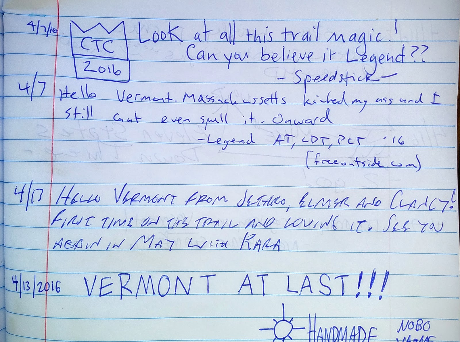
After a short, steep climb I met Handmade, whom I last saw at the RPH Shelter in Hopewell Junction, New York. I finally got to see his handmade (hence his trail name) backpack, replete with what looked to be an Ash frame and canvas bag. Handmade also carries two Bowie knives, an axe pick for digging cat holes, and various other utensils that make his pack top out close to 40 pounds. Despite that excessive weight, he managed to cover 27 miles the day before. He did that by going from 9 a.m. to 1 a.m.; some people are obsessed. 

Before we parted, Handmade felt compelled to comment on the trail conditions, prefacing his remarks with, "you're from here so you probably know these trails well." To which I nodded my head in confirmation, before he proceeded to say how wet they were and for how many miles. Yup, these are New England trails when they are most difficult--before they have dried out:


The best hiking practice is to march right down the middle of that stream/trail, as it prevents further erosion. However, if you don't have waterproof shoes, then be prepared for hours of agonizingly cold feet. And even if you do have waterproof boots, you can't spot the hidden roots, often slanted, that will put you on your ass faster than a speeding bullet. As you can see, many will try to skirt the water, if at all possible.

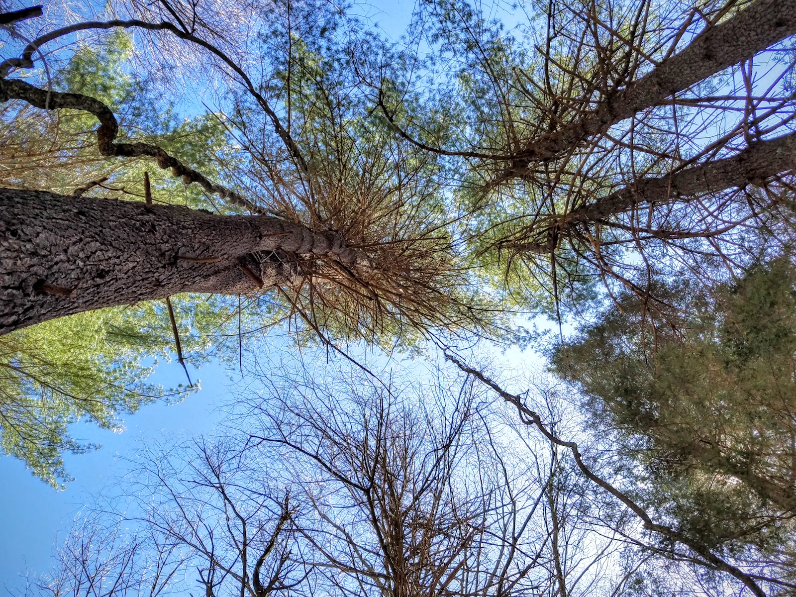
The terrain today was mostly flat with some rolling hills, which explains the wet conditions. There was only one climb up Warner Hill, at 2,050' elevation. In the summer, Warner is renown for its blueberries and red raspberries, but, alas, none were to be seen today. Only the flattened vegetation on the north side of the hill:


For some reason, I found today's hike to be one of the most tiring, not because of the elevation changes, but probably due to the unrelenting water that buried the trail. Without my hiking poles, I most likely would have fallen into those puddles. Staying focused on the trail, rather than on how I was feeling, was hard to do today, but it's over, so now I can look forward to tomorrow.

Route from my Suunto.

Monday, April 11, 2016

Day 11/April 11 -- Sages Ravine to Jug End Road

Miles hiked: 10.05 in 4:46

Starting location: just south of the MA/CT border, near Sages Ravine

Ending location: Jug End Road, South Egremont, MA

Elevation gain: 2,372'


Another overcast day with no views, a little rain, and plenty of water underfoot. I met only one day-hiker heading south as I went north, although I did hear some workers sawing deadfall near the Sages Ravine Campsite.

So, do you want to summit a mountain without finding a crowd there? Here's my advice: First, go on a Monday; all the weekend warriors will be home recovering. Second, pick a cold day. Third, make sure there is rain in the forecast. And fourth, make sure the climb is steep, rocky, and wet. Then the crowds will look like this: 


The summit of Mount Everett, the highest point on today's hike. No crowds, for sure.

And on the north side of Mount Everett, it was very reassuring to know that I was doing things right:


The rest of the trail past Mt. Everett is fairly benign, no big climbs, with good footing. And a nice view, before beginning the steep, rocky descent to the road:


Route from my Suunto.

Sunday, April 10, 2016

Day 10/April 10 -- Falls Village to Salisbury

Miles hiked: 9.09 in 3:23

Starting location: Route 7 and Lime Rock Road, Falls Village, CT

Ending location: Route 44, Salisbury, CT

Elevation gain: 1,745'


Another day with brilliant sunshine, but it was in the low 30sF when we started, and the wind chill dropped that by at least 10°F until we could get into the woods.

I had hiked this a few weeks ago with Bruce Shenker, but we had taken the alternate route on the west side of the Housatonic River, since we thought the iron bridge was still closed. Today, the bridge was open, so Colette and I could follow the usual AT route to the iron bridge.

And when we got to the falls, they were roaring--thanks to the warm weather melting all the recent snowfall.


The climb up Prospect Mountain was the only challenge in today's outing, but we had some company when we met a couple doing an out-and-back from Falls Village to to Prospect, so it went by quickly.

As we got closer to Salisbury, the woods were replete with old-growth pines, which keeps the ground vegetation to a minimum, thanks to their height and light-blocking abilities:


You can get dizzy staring up at the tops.


Spiral staircase to heaven?

Route from my Suunto.